|
| |
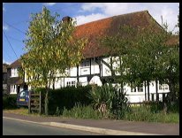
 East Peckham in Kent is a village 12 miles north east of
Royal Tunbridge Wells off the B2106, standing on the banks
of the the Medway. East Peckham in Kent is a village 12 miles north east of
Royal Tunbridge Wells off the B2106, standing on the banks
of the the Medway.
The church of St Michael stands well away from the village,
about 2 miles towards Mereworth . This old church was made
redundant by the 1830's after the community surrounding it
moved away. It still remained in use until 1972 when it finally
closed. The new parish church of the Holy Trinity was built in 1840
within the village.
The village of East Peckham has grown from the amalgamation of
9 separate hamlets, during the early 1900's. The main cause of
this amalgamation was the hop industry, and the dredging of the
river Medway from Maidstone to Tonbridge . This brought with it
the means to transport the hops outside the area.
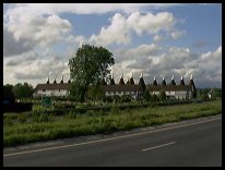
It was once one of the centres of Wealden hop growing. The
Whitbread hop farm at nearby Beltring was the last stronghold
of large-scale, good old fashioned hand picking of hops in Kent.
It was mechanised in 1969, and its massed oast kilns are the
largest group of its kind in the world. It is now open to the
public as a museum and leisure centre.
During the 18th and 19th centuries, East Peckham was one of the
reception areas for London foundlings. The children were sent
here from Thomas Coram's Foundling Hospital, and they were
nursed until they were old enough to be sent back to London. |
|
 East Peckham in Kent is surrounded by the garden of Kent, and has many
orchards and hop gardens. The area is rural, but is quite
accessible with the improvement of the road from the M20 to
the Beltring Hop Farm. East Peckham in Kent is surrounded by the garden of Kent, and has many
orchards and hop gardens. The area is rural, but is quite
accessible with the improvement of the road from the M20 to
the Beltring Hop Farm.
The Hop farm is on the Paddock Wood side of the village, and is
very attractive, with a wide range of attractions. |
|
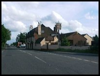 East Peckham in Kent has quite a few shops, and an Industrial Park
with vehicle servicing and other businesses. East Peckham in Kent has quite a few shops, and an Industrial Park
with vehicle servicing and other businesses.
The nearest shopping centre is Maidstone , about 8 miles to
the east.
The nearest trains are at Yalding about 1 1/2 miles away, but
the best service to London is from Paddock Wood about 3 miles
south west. |
|
| East Peckham is shown as the red symbol on the map. |
|
|
Nearby Villages
(click on symbol to see the village page) |
| Village= | |
Town= | |
Recorded in Domesday= |  |
| |
|
|
Boughton Monchelsea |
(Miraculous vision) | | 6.51 miles |
|
|
Coxheath |
(Soldiers and Duels) | | 4.92 miles |
|
|
Hadlow |
(Mays Folly - 150ft tower) | | 2.35 miles |
|
|
Linton |
(Cavalier loses House) | | 5.47 miles |
|
|
Marden |
(Broadcloth and Agriculture) | | 5.29 miles |
|
|
Mereworth |
(The First Victoria Cross) | | 3.22 miles |
|
|
Paddock Wood |
(Railway brings prosperity) | | 2.16 miles |
|
|
Tudeley and Capel |
(Iron Industry and Hop Pickers) | | 3.08 miles |
|
|
Yalding |
(longest medieval bridge in Kent) | | 2.07 miles |
|
|


